

From the Open-Publishing Calendar
From the Open-Publishing Newswire
Indybay Feature
Pacific Lumber Poised to Log Ancient Redwoods Adjacent to State Park
Logging plan boarders Humboldt Redwoods, Highway 101
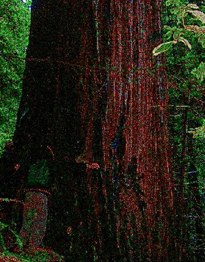
Humboldt County, CA - Signs dotting Northern California’s stretch of Highway 101 declare the scenic passage the “Redwood Highway,” named for ancient redwoods that tower over its flanks. Passing through Humboldt Redwoods State Park, which contains one of the largest remaining contiguous stands of ancient coast redwoods in the world, lengths of the famous thoroughfare are just a stone’s throw to ancient forest owned by Maxxam/Pacific Lumber – redwoods they hope to cut down in the coming weeks.
The 65-acre Timber Harvest Plan (1-04-220 HUM) is habitat for the endangered marbled murrelet and contains many giant redwoods, including some over 10 feet in diameter. The plan, and its close proximity to the park, has drawn criticism from the Department of Parks and Recreation (DPR), who sent a dissenting letter of Non-Concurrence to the California Department of Forestry (CDF). The denuded hillside would create a visual blight to passengers on Hwy 101, as well as those on Avenue of the Giants within the State Park. In this location, the “removal of residual old growth redwoods cannot be visually mitigated.”
DPR also cited a “procedural oversight” in which they were excluded from an inspection that evaluated visual impacts of the harvest area. It was only through a personal communication with a CDF staff forester and related documents that DPR learned of the inspection.
Humboldt Redwoods State Park has suffered environmental damage in recent years, including giant redwoods that toppled when erosion from upstream logging undercut the banks of Bear Creek. Bear Creek lies just a quarter mile from the proposed harvest area.
The local branch of CDF has recommended the plan for approval, stating, “No significant unmitigated cumulative effects are likely to occur.”
Further criticism of the logging plan came from the Regional Water Quality Control Board. After reviewing the proposed logging plan, and the “impaired condition of the water courses” in the plan area, the Water Board “determined that additional protection is warranted” to comply with water protection laws. CDF’s “recommendation for plan approval does not provide adequate protection for the beneficial uses of water, the resource for which the Regional Water Board staff has the responsibility and expertise to protect.”
Approval of the plan would expose visitors to Humboldt Redwoods State Park to the noise pollution of a full-scale industrial logging operation of ancient redwood forest. The explosive sound of a 1,500 year-old tree hitting the ground would damper a peaceful autumn hike through the woods. The resulting aftermath will severely affect both beauty and health of protected forest in the park.
###
Public comment period ends soon!
The deadline for public comment is midnight on November 5. Feel free to use and/or edit this sample letter below. Send public comments by snail mail or email.
California Department of Forestry
Attn: Forest Practice
135 Ridgeway Avenue
Santa Rosa, CA95401
santarosapubliccomment@fire.ca.gov
THP 1-04-220 HUM
To who it may concern,
THP 04-220 must not be approved, as it will contribute significant adverse cumulative effects. The proposed mitigation in the THP is not sufficient to evaluate or meaningfully address these cumulative impacts.
The Eel River is severely impacted by previous harvest operations and is subsequently listed by the EPA as an impaired Watershed. The Eel River provides many beneficial uses that are protected with conservation laws. This protection must be upheld by the reviewing agencies, including CDF, that have a responsibility to asses potential damages to these beneficial uses.
Previously harvested plans adjacent to the proposed THP area will escalate the cumulative adverse impacts and would hinder the recovery of the already impaired watershed.
The THP proposes 3,400 feet of new road construction on a steep ridgeline that drains toward watercourses. This would only add to the already significant cumulative effects of sediment discharge into the Eel River.
According to the Regional Water Quality Control Board, this plan is not in compliance with the Basin Plan. It must be brought into compliance with these standards before approval can be considered.
This Plan is located in an already significantly impaired watershed where harvesting steep areas within close proximity of the riparian area is inappropriate. The sediment generated from such a plan will have a negative effect on water quality in general and will commit trespass of sediment damaging and degrading downstream property including Humboldt Redwoods State Park.
I do not agree with Fortuna CDF’s recommendation for approval and the accompanying statement that “no significant unmitigated cumulative effects are likely to occur” as a result of this THP.
Humboldt Redwoods State Park protects one of the largest remaining contiguous stand of Old Growth Coast Redwoods and its preservation is valued by citizens the world wide. Execution of this THP will visually and environmentally degrade Humboldt Redwoods State Park, damages for which the park and is visitors will not be compensated. The benefits gained by the county from tourism will be diminished, and simultaneously the county would be stuck with the bill for any potential catastrophes (i.e. the Stafford landslide, only four miles Northwest of the proposed THP).
The proposed plan is of great concern due to its location on a steep (up to 100% slope) hillside that exhibits unstable geologic features above US Highway 101. The close proximity of the plan creates health and safety concerns for motorists traveling the highway below.
Please include this comment in the official file for THP 1-04-220 HUM.
Respectfully submitted,
YOUR NAME HERE
YOUR ADDRESS OR EMAIL HERE
Add Your Comments
Latest Comments
Listed below are the latest comments about this post.
These comments are submitted anonymously by website visitors.
TITLE
AUTHOR
DATE
THE GREAT GOLD HEIST
Thu, Nov 4, 2004 1:05AM
Old growth forests grow faster
Thu, Nov 4, 2004 12:13AM
We are 100% volunteer and depend on your participation to sustain our efforts!
Donate

$330.00 donated
in the past month
Get Involved
If you'd like to help with maintaining or developing the website, contact us.
Publish
Publish your stories and upcoming events on Indybay.
Topics
More
Search Indybay's Archives
Advanced Search
►
▼
IMC Network