
From the Open-Publishing Calendar
From the Open-Publishing Newswire
Indybay Feature
Gaza's blocked arteries
It is a public holiday in Gaza - with Eid and the period of official mourning for Yasser Arafat - so there is no better time to sample what it is like for Palestinians travelling through the Israeli-occupied strip.
Gaza is a 40km by 5km (25-mile by three-mile) ribbon of land along the south-east corner of the Mediterranean Sea, home to some 1.3 million Palestinians and 8,000 Jewish settlers.
Gaza is a 40km by 5km (25-mile by three-mile) ribbon of land along the south-east corner of the Mediterranean Sea, home to some 1.3 million Palestinians and 8,000 Jewish settlers.
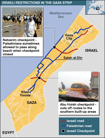
It has - or used to have - a fine two-lane highway called Salah al-Din (Saladin) Street which could whisk you from top to bottom in less than an hour.
Now, with Israel's security regime tightened because of the intifada, Palestinian traffic must zigzag through the territory to avoid Israeli-created obstacles and barriers.
Most inconvenient of all is the total closure, which the Israeli army can impose by cutting the tortuous route at two particular spots, cutting the north, centre and south of Gaza off from each other.
Many Palestinians hope Israeli Prime Minister Ariel Sharon's disengagement plan for Gaza will mean an end to this hardship when the settlers and troops who protect them are pulled out.
Round trip
My journey starts by hailing a taxi from the Gaza City beachfront and requesting a round trip to Khan Younis, the main town in the southern Gaza Strip, about 20km (12.5 miles) away.
A wary look passes across the face of the driver, whose name is Ahmed, but he agrees to take me. I tell him I have three hours, and the wariness turns to outright scepticism.
All right then, I say - if we have to turn round, so be it. But in actual fact, since there is no commuter traffic, no university students, and very little freight, three hours was just about right.
Normally traffic south from Gaza would take Salah al-Din Street, but it is blocked after about 2km (1.2 miles) near the Netzarim settlement. That is where the young Palestinian boy Muhammad al-Durrah was captured being shot dead in TV footage at the beginning of the intifada in 2000.
Now the route out south follows the coastline. The last district you pass at the southern end of Gaza City is Tel al-Hawa, where Hamas leader Sheikh Ahmed Yassin lived and was killed by an Israeli rocket strike earlier this year.
Read More
http://news.bbc.co.uk/2/hi/middle_east/4021095.stm
Add Your Comments
Latest Comments
Listed below are the latest comments about this post.
These comments are submitted anonymously by website visitors.
TITLE
AUTHOR
DATE
Looking at the truth
Fri, Nov 19, 2004 8:47AM
Looking at the truth
Fri, Nov 19, 2004 8:05AM
Blaming the victims for resisting oppression
Thu, Nov 18, 2004 6:35PM
you said it
Thu, Nov 18, 2004 6:24PM
We are 100% volunteer and depend on your participation to sustain our efforts!
Donate

$230.00 donated
in the past month
Get Involved
If you'd like to help with maintaining or developing the website, contact us.
Publish
Publish your stories and upcoming events on Indybay.
Topics
More
Search Indybay's Archives
Advanced Search
►
▼
IMC Network